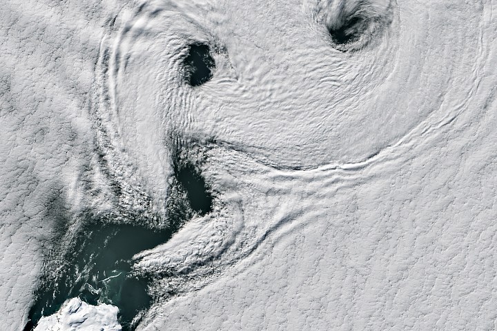
NASA's Earth Observatory captured swirling cloud formations spiraling around Peter I Island, a remote, ice-covered landmass off the West Antarctic coast. The phenomenon occurs when cold ocean air encounters the island's terrain, creating atmospheric turbulence that produces distinctive spiral and comma-shaped cloud patterns visible from orbit.
Peter I Island, located roughly 250 miles from the Antarctic continent, rises sharply from the Southern Ocean. The island's peaks force ascending air to cool and condense, initiating convection patterns that extend far downstream from the landmass. This creates what meteorologists call von Karman vortex streets—repeating spirals of clouds that form when stable airflow encounters an obstacle.
These cloud formations reveal fundamental atmospheric physics in action. The temperature contrast between the frigid Southern Ocean and the island's elevated terrain generates the rotating eddies. Satellite imagery captures this drama at high resolution, showing how small geographic features orchestrate large-scale atmospheric motion across hundreds of kilometers.
Peter I Island remains one of Earth's least accessible locations. The island experiences extreme weather, thick pack ice, and treacherous seas that have deterred sustained human exploration. Satellites provide Earth scientists their best window into conditions at this Antarctic outpost, monitoring cloud patterns, ice extent, and oceanographic features from space.
These observations help scientists understand polar meteorology and climate dynamics. The Southern Ocean drives global ocean circulation and influences weather patterns worldwide. Peter I Island's atmospheric signatures offer clues about how isolated terrain influences regional weather systems and how changing ice conditions alter air-ocean interactions near Antarctica.
THE BOTTOM LINE: Orbital imagery transforms isolated Antarctic islands into natural laboratories for studying how mountains, ice, and atmosphere interact in Earth's most extreme environment.