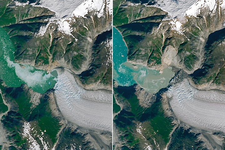
A catastrophic landslide in Tracy Arm, Alaska generated a tsunami in summer 2025 that dramatically reshaped the fjord's shoreline. NASA Earth observation satellites documented the aftermath, capturing the scale of vegetation loss along the glacial inlet.
The event unfolded in one of Alaska's most dynamic coastal environments. Tracy Arm cuts through the Chugach Mountains, terminating at two tidewater glaciers that calve directly into the fjord. This setting combines active glacial retreat, steep unstable slopes, and deep water, creating conditions ripe for sudden geomorphic change.
The tsunami, triggered by rock and ice material cascading into the fjord, swept across the water with enough force to strip vegetation from shorelines that had been colonizing the newly deglaciated terrain. NASA's satellite imagery reveals the post-event landscape in stark detail. Where coastal vegetation previously established itself on recently exposed land, the tsunami scoured surfaces back to bare rock and sediment. The contrast between pre- and post-event satellite passes provides an unambiguous record of the disturbance.
This event illustrates how rapidly Alaska's glacial regions transform. As glaciers retreat under warming conditions, they expose loose, unstable slopes. Landslides become more frequent. Meanwhile, coastal ecosystems that have only recently begun recolonizing exposed terrain face periodic erasure from geomorphic hazards. The 2025 Tracy Arm tsunami represents one snapshot in this accelerating cycle.
For researchers studying glacial systems and coastal dynamics, NASA's Earth observation data provides baseline documentation of these changes. Understanding the frequency and magnitude of landslide-tsunami events in Alaskan fjords informs hazard assessment and coastal management decisions. The fjord environment becomes a natural laboratory for observing how climate change cascades through interconnected physical systems.
THE TAKEAWAY: Rapid glacial retreat in