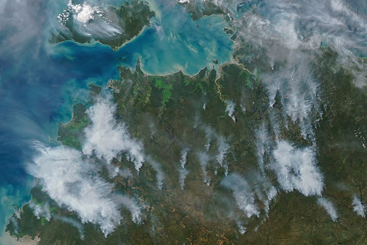
NASA satellite data reveals how prescribed burns in Australia's Northern Territory reshape fire dynamics across fire-prone ecosystems. Researchers use controlled, early-season burns to reduce fuel loads and alter vegetation structure, preventing the catastrophic wildfires that arrive later in the year with higher temperatures and drier conditions.
The Northern Territory experiences intense fire seasons that threaten landscapes, infrastructure, and lives. Traditional suppression alone proves insufficient in these arid and semi-arid regions where vegetation accumulates as fuel. Prescribed burns, ignited under controlled conditions when weather permits safer management, consume accumulated plant matter before natural ignition sources trigger uncontrolled blazes.
NASA's Earth-observing satellites, including instruments aboard Landsat and the MODIS sensor on Terra and Aqua, track burn progression and vegetation recovery across the territory. These platforms detect thermal signatures from active fires and measure changes in vegetation indices over time, allowing fire managers to assess burn effectiveness and plan future interventions.
The approach stems from knowledge held by Indigenous Australian peoples who managed fire on the continent for tens of thousands of years. Modern fire management integrates this ecological understanding with satellite monitoring to create a more sustainable fire regime. Early-season burns reduce intensity when subsequent fires ignite, lowering temperatures and flame lengths that would otherwise crown through forests and destroy soil structure.
Data from NASA observations show that areas receiving prescribed burns experience less severe subsequent wildfires, lower carbon emissions, and faster vegetation recovery. The strategy also supports wildlife habitat management, as some ecosystems depend on fire for seed germination and nutrient cycling.
This work demonstrates how space-based Earth observation enhances ground-based land management. Fire managers access near-real-time satellite data to optimize burn timing and location, improving outcomes across thousands of square kilometers. The Northern Territory's prescribed burn program, supported by NASA data and Indigenous land management practices, offers a model for other fire-prone regions globally seeking sustainable alternatives