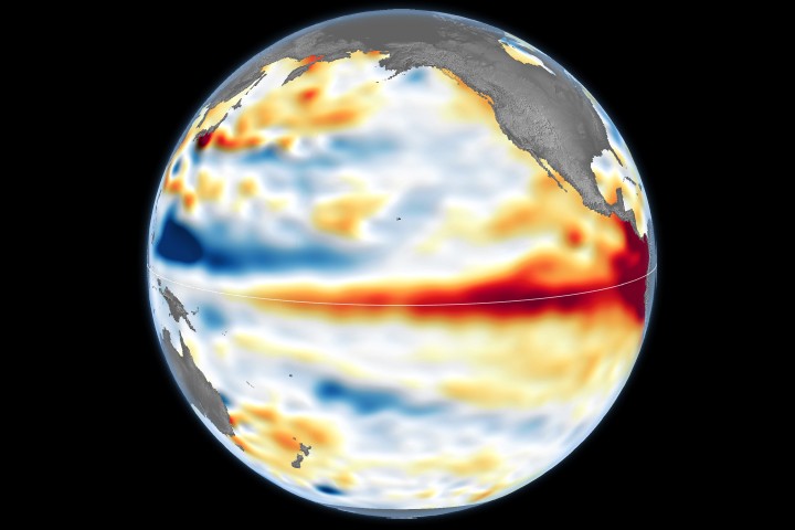
NASA satellite data confirms El Niño conditions intensified across the tropical Pacific Ocean during early June 2026. Sea surface height measurements, tracked through advanced orbital instruments, show the warming pattern gaining strength as it progresses through the Southern Hemisphere's winter season.
El Niño events emerge when warm water spreads across the equatorial Pacific, disrupting global weather patterns and atmospheric circulation. The phenomenon drives torrential rainfall in some regions while triggering droughts in others. Monitoring these ocean conditions with satellite precision allows meteorologists and climate scientists to forecast impacts months in advance across agriculture, water resources, and coastal communities worldwide.
NASA's satellite constellation measures sea surface height with centimeter-level accuracy using radar altimetry. These instruments detect the subtle bulges and dips in ocean topography caused by temperature variations and water density shifts. Higher sea surface heights in the tropical Pacific correspond to accumulated warm water, a hallmark of developing El Niño conditions. Real-time tracking from space enables researchers to distinguish El Niño from its counterpart, La Niña, and to gauge intensity as events evolve.
The 2026 El Niño's strengthening phase carries operational significance for meteorological agencies preparing seasonal forecasts. Climate models incorporate satellite observations to predict where this warming will redistribute atmospheric energy, affecting precipitation and temperature patterns from the Americas to Asia. Historical El Niño events have triggered crop failures, altered fish populations critical to food security, and shifted hurricane patterns in the Atlantic basin.
Satellite Earth observation remains the backbone of El Niño monitoring because ground stations cannot capture the vast spatial scope of tropical Pacific warming. NASA's commitment to continuous ocean surveillance through missions carrying radar altimeters ensures scientists maintain the long-term dataset needed to distinguish natural climate variability from human-induced climate change. This continuity allows researchers to identify trends and improve predictive models for future events.