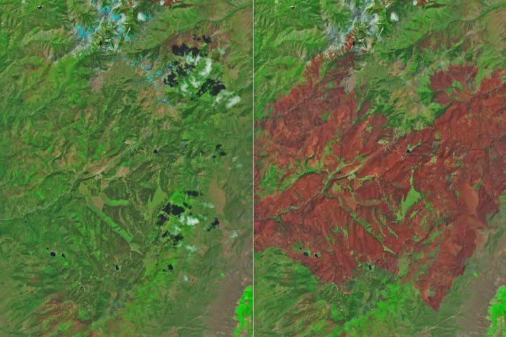
NASA satellites tracked the Cottonwood Fire as it consumed over 150 square miles across Utah, including portions of a ski resort area. The agency's Earth-observing instruments captured thermal imagery of the active burn zones, providing real-time data for firefighting operations and evacuation coordination.
NASA's satellites, including those carrying the Moderate Resolution Imaging Spectroradiometer (MODIS) sensors, detect heat signatures from wildfires across North America. The Cottonwood Fire demonstrated how space-based monitoring systems help ground crews understand fire behavior, spread patterns, and intensity in near-real time. This data proves essential for managing resources across sprawling burn areas where ground visibility remains limited.
The fire's progression through developed terrain, including resort infrastructure, highlighted the vulnerability of populated regions in fire-prone landscapes. Satellite thermal detection allows incident commanders to identify active hot spots, predict fire movement based on topography and wind patterns, and coordinate evacuation timing more effectively than ground observation alone could provide.
NASA's fire-monitoring capabilities stem from decades of Earth science missions designed to track environmental hazards. The same satellites that monitor atmospheric composition, ocean temperatures, and vegetation health also serve critical roles during natural disasters. MODIS instruments aboard the Terra and Aqua satellites pass over the same ground location multiple times daily, creating a temporal record of how wildfires evolve.
The Cottonwood Fire underscores growing challenges for Western states facing longer fire seasons driven by climate conditions that satellites also help document. By tracking vegetation moisture levels, surface temperatures, and fuel availability across seasons, NASA data informs long-term fire risk assessments and forest management strategies.