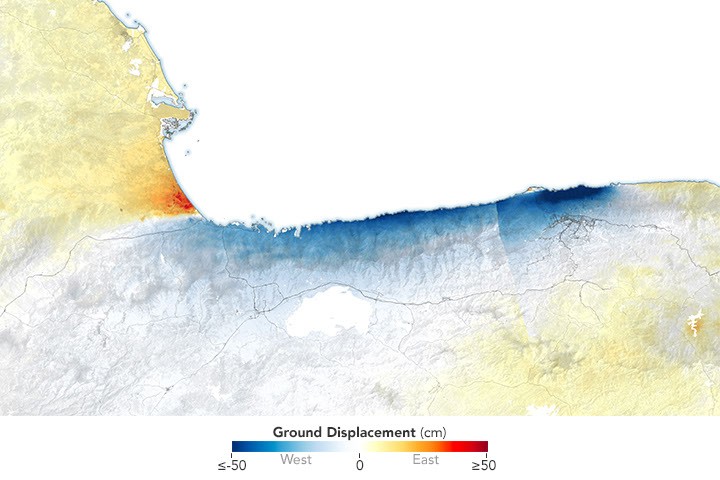
NASA's NISAR satellite has mapped ground displacement from Venezuela's June 2026 earthquakes with unprecedented precision. The radar instrument detected substantial shifts in terrain around La Guaira and surrounding regions following the seismic events.
NISAR, the NASA-ISRO Synthetic Aperture Radar mission, uses advanced radar interferometry to measure millimeter-level changes across Earth's surface. The satellite bounces microwave signals off the ground and analyzes how the returning signals shift, revealing exactly where and how much the earth moved during the tremors.
The data from Venezuela demonstrates NISAR's capability to rapidly characterize earthquake impacts across large areas. This information proves essential for understanding fault mechanics, assessing infrastructure damage, and planning emergency response. Ground displacement maps help geophysicists identify which fault segments ruptured and estimate the earthquakes' magnitudes and stress release patterns.
La Guaira, Venezuela's primary Caribbean port city, sits in a tectonically active region where the Caribbean and South American plates interact. The June earthquakes exposed the complex strain accumulation along these plate boundaries. NISAR's observations reveal whether the ruptures occurred on known faults or previously unmapped segments.
This marks a major application of NISAR's operational capability. The satellite, launched in January 2024 through collaboration between NASA and the Indian Space Research Organisation, conducts systematic monitoring of Earth's surface deformation. Its radar system penetrates cloud cover and operates day and night, advantages over optical imagery in tropical regions like Venezuela where persistent clouds hamper traditional satellite observations.
The displacement measurements feed into hazard assessments and contribute to understanding long-term earthquake cycle behavior. By tracking how strain redistributes after major earthquakes, scientists refine models predicting future seismic activity. NISAR's systematic global monitoring establishes a baseline for detecting subtle ground movements that precede volcanic eruptions, landslides