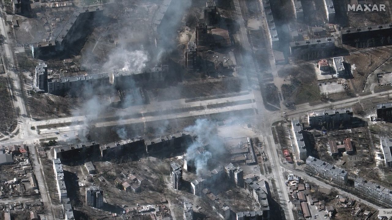
# Satellites Become Witnesses to War and Human Rights Atrocities
Earth observation satellites have emerged as an impartial record-keeper for conflicts and atrocities across the globe. From documenting mass graves in Ukraine to tracking forced labor camps in Myanmar, commercial and government-operated imaging platforms provide evidence that ground-based reporting struggles to capture. These orbital perspectives create documentation that persists long after propaganda and denial fade.
The technology works through optical and radar imaging systems aboard satellites in low Earth orbit. Platforms like Planet Labs' Dove constellation, Maxar Technologies' WorldView series, and European Space Agency's Copernicus Sentinel missions capture imagery with resolutions down to 30 centimeters per pixel in some cases. This precision allows analysts to identify destroyed structures, displaced populations, mass burial sites, and infrastructure damage with unprecedented clarity.
Organizations including Human Rights Watch, Amnesty International, and the International Criminal Court leverage these images to build investigative records. When ground access becomes impossible or reporting carries mortal risk, satellites provide environmental evidence. Thermal imaging detects heat signatures inconsistent with ordinary activity. Multi-temporal analysis reveals changes in settlement patterns, the construction of detention facilities, and the systematic erasure of communities.
Ukraine demonstrated this capability during Russia's 2022 invasion. Satellite imagery documented mass graves in Bucha, Hostomel, and other towns, providing visual corroboration of atrocities. The images appeared within days of events, compressing the timeline between crime and documentation. Researchers compared sequential imagery to establish patterns of destruction and human rights violations before ground investigators could access sites.
But significant obstacles persist. Cloud cover obscures vision from above. Authoritarian governments restrict satellite data access or deny imaging requests. Commercial imaging companies balance humanitarian use with business relationships in nations of concern. Satellite passes over target areas occur on fixed schedules, sometimes providing only sporadic coverage. Economic constraints limit how much imagery is purchased and analyzed.
The legal framework remains unresolved. Evidence from satellites increasingly appears in International Criminal Court proceedings, yet admissibility standards vary. Metadata, chain of custody, and interpretation methodology all face scrutiny. Defense teams question resolution quality and the potential for misidentification or misinterpretation by analysts lacking ground-level expertise.
Integration with open-source intelligence networks has accelerated the process. Researchers cross-reference satellite data with social media posts, drone footage, eyewitness accounts, and communications intercepts. This layered approach creates more robust evidentiary packages than any single source provides.
The proliferation of small satellites changes the equation. Constellations like Maxar's WorldView and Planet's Dove network generate dozens of passes daily over conflict zones. The volume of imagery increases the probability of capturing moments of significance. Processing algorithms powered by machine learning identify changes automatically rather than relying solely on manual review.
Nations and international bodies now budget specifically for satellite monitoring of human rights concerns. The United Nations, European Union, and individual states subscribe to satellite services. Ukraine's government contracted commercial imaging services to monitor Russian military movements and document destruction.
The challenge ahead involves democratizing access. Poorer nations and smaller NGOs lack resources to purchase high-resolution imagery. Humanitarian organizations advocate for subsidized or free access to Earth observation data for atrocity documentation. Some governments and platforms have begun releasing imagery publicly when conflicts reach critical phases, creating temporary windows of transparency.
Satellites cannot prevent atrocities. They cannot arrest perpetrators. But they create records that persist beyond immediate conflicts. They make denial harder and accountability more achievable. In a world where regimes attempt to control narratives through information control, a camera above the atmosphere provides perspective no propagandist can fully suppress.