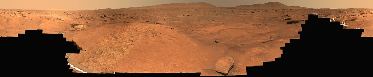
NASA's Perseverance rover has assembled a sweeping 360-degree panorama of "Turquoise Bay," a geologic formation on Mars that reveals layered mineral deposits and erosional patterns the science team considers high-priority targets for investigation.
The rover's Mastcam-Z camera captured 818 individual frames between October 5 and October 16, 2023, spanning sols 933 through 944 of the mission. Stitching these images together produced a panoramic view that documents the subsurface geology of the "Margin Unit," a region within Jezero Crater where the rover has been conducting detailed reconnaissance since its August 2021 landing.
Turquoise Bay derives its designation from the distinctive coloration visible in the panorama. Mars rovers employ natural-color imaging to reveal mineral composition and weathering patterns that invisible-light wavelengths cannot capture as effectively. The turquoise hues suggest the presence of hydrated minerals or iron-bearing rocks that have undergone specific oxidation processes. These color variations serve as breadcrumbs for Perseverance's science team to identify where water-rock interactions occurred in Mars' past.
The Margin Unit sits at a geological boundary zone where different depositional environments transition into one another. These transition zones concentrate evidence of Mars' hydrological history. Water flowed through and across these boundaries billions of years ago, leaving mineral signatures that persist today. Perseverance's mission centers on detecting these signatures and understanding what ancient Martian conditions enabled the chemistry that could have supported microbial life.
Mastcam-Z represents a technological leap beyond the Curiosity rover's monolithic Mastcam system. The newer camera features a zoom lens ranging from 24 millimeters to 110 millimeters focal length, comparable to a consumer telephoto camera. This zoom capability permits both wide environmental context and fine detail of distant rock formations without requiring the rover to move closer. For a six-ton vehicle traversing rugged, boulder-strewn Martian terrain, every meter traveled expends battery power and risks mechanical failure. Remote imaging reduces unnecessary movement.
The engineering behind the panorama reflects Perseverance's core design philosophy. Rather than streaming continuous video like Earth-based cameras, Mars rovers acquire discrete image sequences that ground teams download and process. Communications lag between Earth and Mars ranges from 5 to 20 minutes depending on orbital geometry. Rovers operate with pre-programmed autonomy. The rover acquired these 818 frames across an 11-day period as a low-priority background task while other instruments investigated nearby samples.
Perseverance's science team prioritized Turquoise Bay for panoramic documentation because the layering patterns visible in erosion escarpments tell stories about Jezero Crater's water history. Layered formations typically accumulate in water-dominated environments. The specific sequence and thickness of each layer encode information about water persistence, chemistry, and flow direction. Reading this geological text requires multiple angles and high resolution. The 360-degree panorama provides that comprehensive view.
The Perseverance mission operates under the Astrobiology Research Integrated with Geological Exploration framework, or ARIES. This protocol shapes rover navigation to prioritize sites where ancient habitability evidence concentrates. Turquoise Bay qualified for this intensive documentation approach. The rover will likely circle back to acquire drill samples from accessible outcrops. Those samples will undergo analysis with Perseverance's Sample Analysis at Mars instrument suite, measuring organic compounds and isotopic ratios that indicate whether chemical complexity sufficient for metabolism ever emerged in Martian brines.