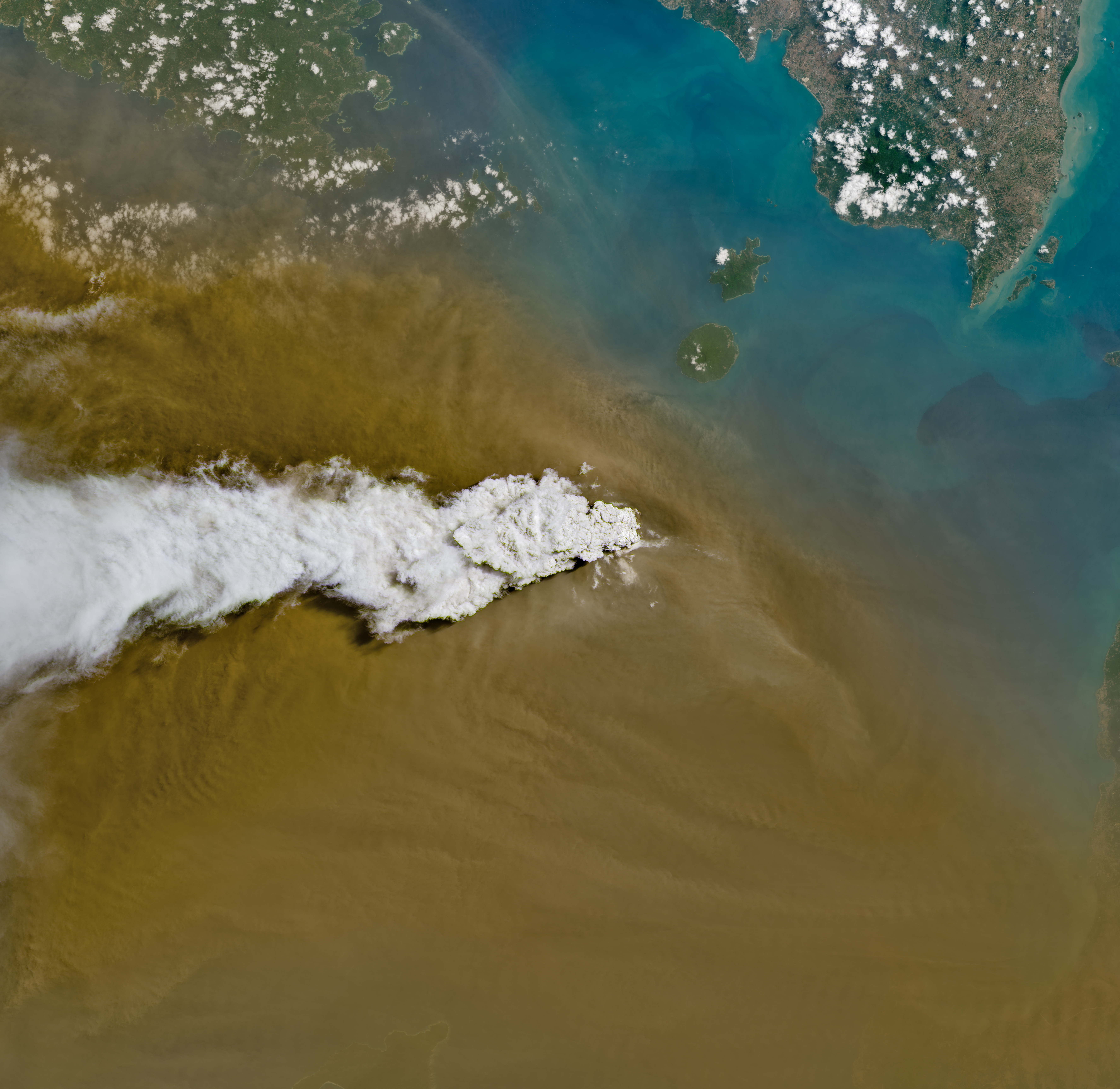
# Indonesia's Anak Krakatau Captured in Violent Eruption by Landsat 8
NASA's Landsat 8 satellite captured Anak Krakatau mid-eruption on September 5, 2026, revealing the volatile volcano in its element as it discharged ash and volcanic gases across the Sunda Strait between Java and Sumatra. The image, acquired using the Operational Land Imager, or OLI, documents the ongoing geological turbulence that defines this small but potent volcano.
Anak Krakatau, whose name translates to "Child of Krakatau," emerged from the ocean floor in 1927, roughly four decades after its parent volcano, Krakatau, catastrophically exploded in 1883 in one of history's deadliest eruptions. The offspring has grown into an active stratovolcano that dominates the narrow waterway separating two of Indonesia's largest islands. Since its formation, it has remained in near-constant motion, with eruptions varying from routine gas emissions to more explosive events capable of generating tsunami waves.
The Landsat 8 observation represents part of a long-term monitoring program that tracks volcanic activity across the planet. Launched in 2013 as a collaboration between NASA and the U.S. Geological Survey, Landsat 8 carries the Operational Land Imager as its primary instrument, capturing multispectral imagery at 30-meter resolution across visible, near-infrared, and shortwave-infrared wavelengths. This capability allows scientists to detect heat signatures from lava, distinguish ash plumes from clouds, and monitor changes in the volcano's morphology over time.
Anak Krakatau's eruptive patterns serve researchers studying subduction zone volcanism. The volcano sits in the Ring of Fire, that horseshoe-shaped belt of active volcanoes and seismic zones encircling the Pacific Ocean. The subduction of the Indo-Australian Plate beneath the Eurasian Plate fuels the magmatism that powers this system. Understanding how Anak Krakatau releases pressure through eruptions helps volcanologists assess hazard levels for nearby population centers.
The region around Anak Krakatau is densely populated. Java alone holds over 140 million people, and communities in the Sunda Strait region depend on shipping lanes that pass directly over the volcano's submarine flanks. A major eruption could generate destructive waves. The December 2018 event, which killed over 400 people and displaced thousands, demonstrated the real-world stakes of living in volcanic terrain. Landsat 8's continuous surveillance helps Indonesian authorities at the Center for Volcanology and Geological Hazard Mitigation identify patterns that might signal escalation toward larger events.
The September 2026 image adds another data point to a decades-long archive. Landsat satellites have observed Anak Krakatau since the 1970s, creating a geological record that reveals growth rates, slope stability, and changes in eruptive intensity. Each eruption captured by OLI contributes to machine learning models designed to forecast behavior and issue timely warnings to the surrounding population.
Routine monitoring of active volcanoes like Anak Krakatau demonstrates how space-based Earth observation serves both scientific inquiry and public safety. The satellite does not predict eruptions, but it documents the volcano's ongoing conversation with the planet's interior, translating invisible geophysical processes into visible data that protects lives downstream.