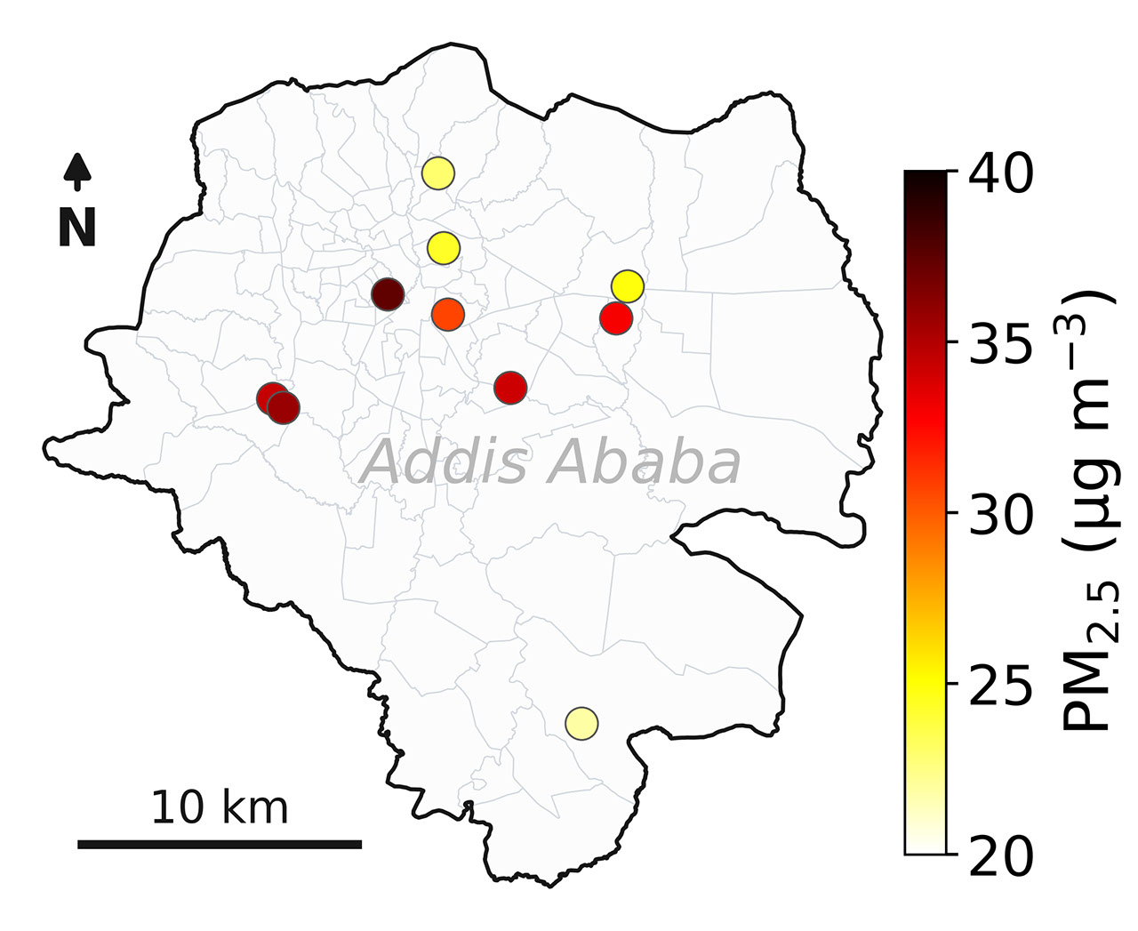
NASA deployed 10 ground sensors across Addis Ababa as part of the Multi-Angle Imager for Aerosols (MAIA) mission, creating one of the most comprehensive air pollution datasets ever collected for an African city. The three-year measurement campaign tracked fine particulate matter (PM2.5), particles 2.5 micrometers or smaller that penetrate deep into human lungs and enter the bloodstream.
MAIA pairs satellite observations with surface-level monitoring to map aerosol distribution at unprecedented spatial resolution. The sensors positioned throughout Ethiopia's capital city gathered continuous ground-truth data that validates and calibrates the satellite instruments orbiting overhead. This dual approach transforms air quality monitoring from broad regional estimates into street-level precision maps showing exactly where pollution concentrations spike and fluctuate.
PM2.5 pollution poses direct health threats. These ultrafine particles bypass the body's natural respiratory defenses and lodge in the alveoli, triggering inflammation, cardiovascular stress, and respiratory disease. The World Health Organization links chronic PM2.5 exposure to premature death. In rapidly urbanizing African cities like Addis Ababa, where vehicle emissions, industrial activity, and biomass burning converge, understanding pollution patterns becomes essential for public health planning.
The MAIA mission launched in April 2018 aboard an International Space Station resupply mission. The instrument observes Earth from multiple angles, allowing scientists to distinguish aerosol properties like size, composition, and altitude. By correlating satellite data with ground-based PM2.5 measurements, MAIA researchers developed algorithms that improve aerosol retrieval accuracy over urban areas where pollution patterns prove complex and heterogeneous.
Addis Ababa presented an ideal testing ground. The city's elevation (2,355 meters above sea level), complex topography, and diverse pollution sources create challenging atmospheric conditions for satellite remote sensing. Validating MAIA against dense ground networks in such environments strengthens the mission's ability to detect aerosol changes globally.
The three-year campaign produced critical insights into Addis Ababa's seasonal pollution cycles and diurnal patterns. Air quality fluctuates based on meteorological conditions, traffic cycles, and regional biomass burning from agricultural activities. MAIA's detailed measurements revealed how these factors interact to shape exposure patterns across different neighborhoods and time periods. This granular understanding enables targeted interventions.
Results from the Addis Ababa deployment directly inform urban air quality management in the Ethiopian capital and provide a replicable model for other developing cities. Policymakers can use MAIA-generated maps to identify hotspots requiring emission controls or population relocation efforts. Public health officials can target pollution reduction campaigns toward the neighborhoods facing the highest chronic exposure.
The mission's success in Addis Ababa demonstrates how space-based remote sensing, when anchored by robust ground networks, delivers actionable intelligence for cities facing acute air pollution challenges. MAIA continues operations, with researchers working to expand ground validation networks in other regions where air quality data remains sparse but health impacts run deep. This combination of orbital and surface measurements represents the future of global air quality monitoring, translating satellite views into local solutions that protect human health in cities worldwide.