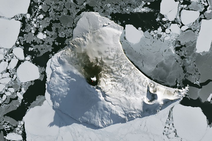
# A Bright Spot at Mount Michael
A thermal satellite image captured volcanic activity at Mount Michael, a remote volcano on Livingston Island in the South Atlantic, as austral winter conditions began clearing in late August. NASA's Earth observation instruments detected the heat signature of active lava at the volcano's summit, providing rare documentation of ongoing geological processes in one of Earth's most isolated regions.
Mount Michael sits within the South Shetland Islands, a territory claimed by the United Kingdom and located approximately 900 kilometers northeast of the Antarctic Peninsula. The volcano last erupted in 2015, and this thermal detection indicates continued magmatic activity beneath the surface. The remote location and harsh winter weather conditions severely limit ground-based monitoring of the volcano, making satellite thermal imaging the primary method for tracking its behavior.
The observation came from NASA's Landsat 8 satellite, which carries the Thermal Infrared Sensor (TIRS) instrument. This sensor detects radiation in the thermal infrared spectrum, allowing it to distinguish heat signatures invisible to conventional cameras. The wavelengths captured by TIRS penetrate atmospheric haze and clouds that would obscure visible-light imagery, making it uniquely suited for monitoring volcanic activity in regions prone to persistent cloud cover.
Livingston Island hosts one of Earth's most inhospitable research environments. Multiple national scientific stations operate on the island, but the volcano itself remains largely inaccessible during winter months, when sea ice thickens and temperatures plummet below minus 20 degrees Celsius. The South Shetland Islands lie at approximately 62 degrees south latitude, placing them well within the Southern Ocean's stormiest regions.
Thermal monitoring of remote volcanoes serves multiple purposes for Earth scientists. Changes in heat output can signal shifts in volcanic behavior, potentially indicating increased pressure in the magma chamber or changes in eruption style. These observations help volcanologists worldwide understand how Antarctic volcanoes interact with the surrounding cryosphere. Mount Michael's activity also influences the local ice environment. Heat from active lava can melt surrounding glaciers and ice fields, creating unique ecosystems and affecting regional water balance.
The detection underscores the value of Earth observation satellites for scientific research on planets. The same thermal imaging technology that monitors Antarctic volcanoes also observes geological activity across all continents, tracks volcanic hazards near populated areas, and studies volcanic interactions with climate systems. NASA maintains a constellation of Earth observation satellites specifically designed to provide continuous global monitoring of planetary processes.
Livingston Island's research community includes scientists from Argentina, Bulgaria, Chile, China, Japan, South Korea, Russia, Spain, and Uruguay. These stations operate under Antarctic Treaty protocols, establishing the continent as a zone for scientific cooperation rather than territorial dispute. Shared access to satellite data benefits all participating nations, enabling coordinated study of Antarctic geological and environmental systems.
As austral winter fully retreats in the coming months, improved observing conditions will likely yield additional thermal images. Scientists will track whether heat signatures at Mount Michael remain stable or intensify, providing early warning of any shift toward more vigorous volcanic activity. These observations contribute to a long-term database of Antarctic volcano behavior that spans decades, essential for understanding Earth's internal heat and the dynamic relationship between tectonics and the polar environment.