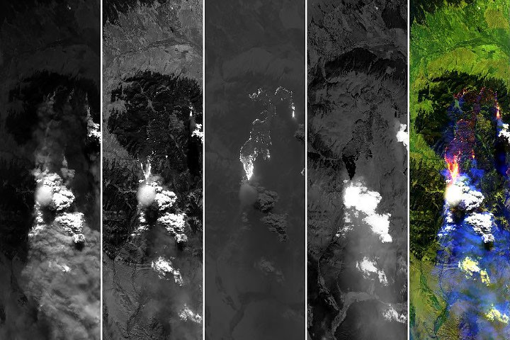
A pileus cloud formation swept across the skies above a Montana wildfire, offering scientists an uncommon glimpse into the atmospheric dynamics that produce these rare, delicate structures. NASA researchers documented the event, capturing detailed observations of the ephemeral cloud that crowned a towering smoke plume.
Pileus clouds form when air rises rapidly and cools, causing water vapor to condense into a thin, smooth cap that sits atop a larger cloud mass. The phenomenon occurs in specific atmospheric conditions where wind shear, temperature gradients, and moisture levels align precisely. These formations typically persist for only minutes before dissipating, making direct observation challenging and valuable for meteorological study.
The wildfire context amplified the scientific value of this sighting. Intense surface heating from the flames drove a powerful updraft that lifted the smoke plume to substantial altitude. As the superheated air mass rose and expanded into cooler atmospheric layers, water vapor condensed around aerosol particles from the smoke itself. The result created a capping cloud that appeared to balance atop the column like a lens or smooth pancake resting on a mushroom stem.
Pileus clouds hold importance beyond their visual intrigue. They provide direct evidence of atmospheric instability and convective processes. Researchers study these formations to refine models of vertical air motion, cloud microphysics, and how aerosols interact with water droplet formation. Wildfire smoke complicates this picture further, as particulates alter typical condensation nuclei patterns and can modify cloud properties in ways that standard meteorological instruments struggle to capture.
The NASA observation contributes to a growing archive of pileus cloud documentation. While meteorologists have studied these structures for decades, systematic cataloging remains incomplete. Each new sighting adds data points that improve understanding of when and where pileus clouds form, what conditions favor their persistence, and how they interact with surrounding atmospheric layers.
Climate and weather forecasting benefit from this knowledge. Pileus clouds sometimes signal the approach of severe weather, including thunderstorms and updrafts strong enough to reach the stratosphere. Detecting and interpreting these signals requires recognizing the full spectrum of cloud formations and the atmospheric signatures they represent.
Wildfire season across the western United States produces numerous opportunities for such observations. Smoke plumes reach kilometers into the atmosphere, creating the exact conditions where pileus clouds emerge. Researchers monitoring fire behavior increasingly incorporate atmospheric observation into their toolkit, capturing imagery that yields insights spanning meteorology, aerosol physics, and climate dynamics.
The image of a delicate pileus cap floating above roiling smoke demonstrates nature's complexity. Wildfires generate raw power that reshapes the lower atmosphere, while simultaneous microphysical processes sculpt cloud structures of remarkable delicacy. Understanding both requires continuous observation and refined measurement techniques. Each documented instance advances the science and prepares forecasters for future atmospheric phenomena.