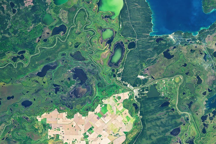
# Agricultural "Island" in the Saskatchewan River Delta Reveals Climate Shifts in Northern Manitoba
NASA satellite imagery has captured a striking transformation unfolding across Manitoba's northernmost farmland. The agricultural plots near The Pas, located within the sprawling Saskatchewan River Delta, shift from verdant green to drought-stressed brown across the 2026 growing season. The change illustrates how climate variability impacts food production at the edge of Canada's cultivated frontier.
The Saskatchewan River Delta, one of North America's largest inland deltas, spans portions of Saskatchewan and Manitoba. Its wetlands and waterways create a unique landscape where farming pushes into marginal territory. The Pas sits at approximately 54 degrees north latitude, making agriculture here a resilience test against short growing seasons, variable precipitation, and permafrost proximity. Farmers in this region operate within tight margins, dependent on moisture availability during critical growth phases.
NASA Earth observation satellites captured the browning progression through multispectral imaging. Such data tracks vegetation health by measuring how plants reflect light at different wavelengths. When crops experience water stress, they reflect less near-infrared radiation. The visible browning across the 2026 season suggests either drought conditions or unexpected frost events disrupted normal development cycles.
The timing of this observation carries broader implications. Climate change has already pushed growing season boundaries northward in western Canada. Warmer temperatures extend the frost-free window, theoretically opening new farmland. However, the same climate system introducing longer seasons also generates unpredictable moisture swings. Wet springs can delay planting. Dry mid-summers can devastate established crops. Unseasonal frosts can wipe out gains from extended growing periods.
Earth observation plays an expanding role in agricultural monitoring. Satellites like those in NASA's Landsat mission collect imagery every eight to sixteen days at 30-meter resolution. Farmers and researchers use this data to track crop health, predict yields, and manage water resources. In northern agriculture, where margins are thin and climate volatility high, satellite-based early warning systems inform decisions about replanting, insurance claims, and regional food security assessments.
The Saskatchewan River Delta itself represents a region of planetary interest beyond agriculture. Its wetlands rank among the world's most productive freshwater ecosystems. They support migratory waterfowl populations, fish spawning grounds, and carbon storage in peat soils. Agricultural expansion into these areas involves tradeoffs between food production and ecosystem preservation. Satellite data revealing crop stress helps stakeholders evaluate whether marginal farmland remains economically viable or should revert to wetland restoration.
NASA's observation of this agricultural island surrounded by water and wetlands documents a real-time climate adaptation challenge. Northern farming communities cannot simply shift planting dates or crop varieties overnight. Investment in equipment, infrastructure, and experience anchors operations in place. Yet climate systems grow increasingly volatile. The visible browning of fields near The Pas in 2026 provides concrete evidence that farming at environmental frontiers requires constant recalibration and adaptive management.