# El Niño Then and Now: What 35 Years of Satellite Data Reveals
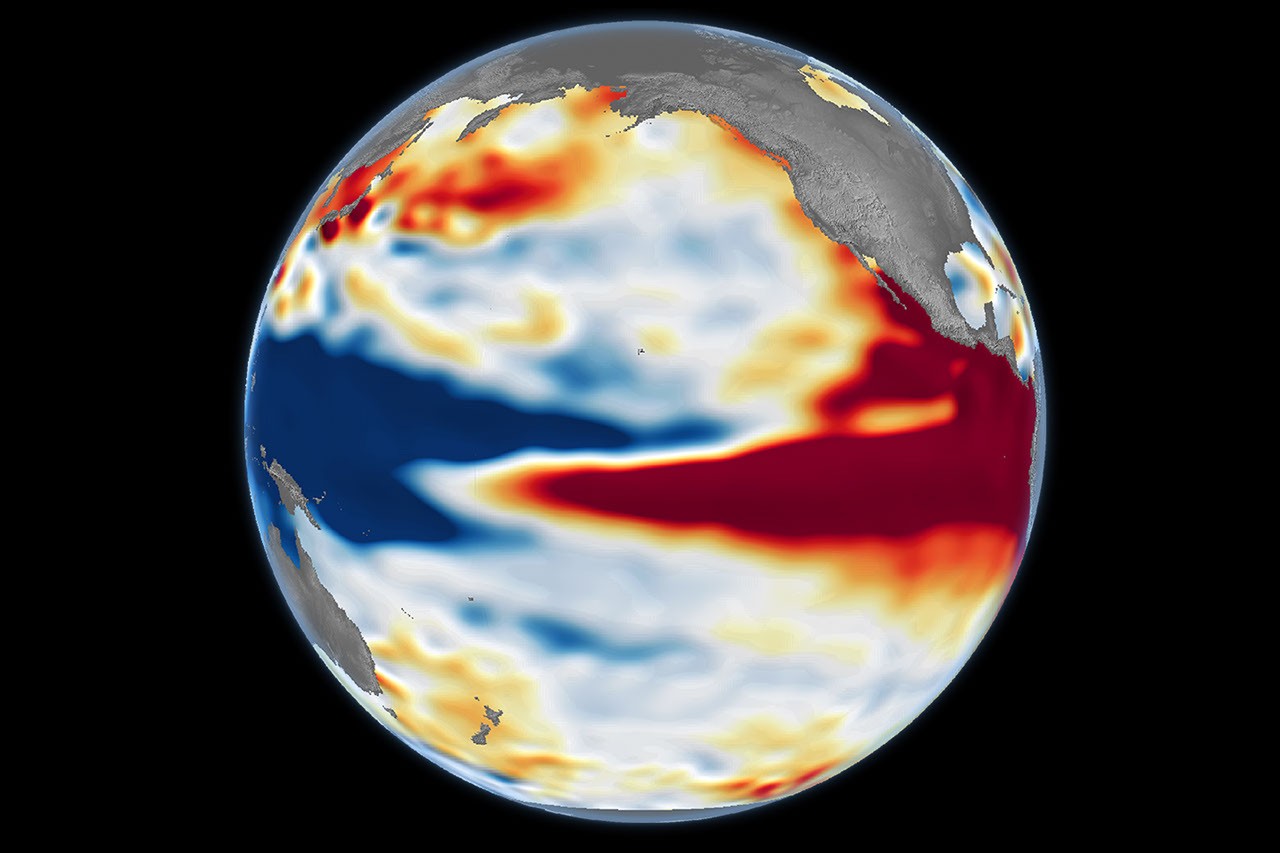
NASA scientists deployed satellite altimetry to measure ocean surface heights with unprecedented precision, creating a continuous record spanning 35 years. This dataset now allows researchers to directly compare the 2023-2024 El Niño event against the strongest historical episodes on record, providing hard data to distinguish seasonal climate swings from long-term planetary trends.
El Niño events, which occur irregularly every few years, warm the tropical Pacific Ocean and reshape weather patterns across the globe. Rainfall patterns shift. Hurricanes intensify in certain regions while diminishing in others. Agricultural zones experience drought or flooding. The 1997-1998 El Niño and the 1982-1983 event stand as benchmarks for extreme conditions. Both events caused widespread crop failures, wildfires, and economic disruption. Now scientists can measure how the current episode stacks up.
Satellite altimeters measure sea surface height with centimeter-level accuracy by timing how long radar pulses take to bounce off the ocean and return to the satellite. Since the TOPEX/Poseidon mission launched in 1992, a succession of altimeter satellites, including Jason-1, Jason-2, Jason-3, and Sentinel-6, maintained continuous coverage. These instruments detect subtle changes in water depth across ocean basins. Warm water expands, raising sea level slightly. Cold water contracts, lowering it. By reading these signatures, scientists map temperature anomalies across thousands of kilometers without ever touching the water.
The 35-year altimetry archive revealed that the 2023-2024 El Niño matched or exceeded the intensity of the 1997-1998 event in certain metrics. Sea surface height anomalies in the central and eastern tropical Pacific reached among the highest values in the satellite record. Ocean heat content, derived from these measurements, climbed to historic levels. This matters because warmer oceans contain more energy, intensifying storms, accelerating ice melt, and pushing heat into the atmosphere at faster rates.
The comparison also exposed something unexpected. While the 2023-2024 El Niño produced extreme sea surface heights, the atmospheric response in some regions appeared dampened compared to 1997-1998. Scientists attribute this to background warming from greenhouse gas emissions. The entire tropical Pacific now runs warmer than it did in the 1990s. An El Niño superimposed on this warmer baseline produces different regional impacts than an El Niño riding a cooler ocean.
Satellite altimetry fundamentally changed climate science. Before these tools existed, scientists relied on scattered ship observations and buoys to infer ocean conditions across vast regions. The data were sparse, delayed, and uneven in coverage. Satellites transformed oceanography into a near-real-time global enterprise. Modern forecasters now issue El Niño predictions months in advance. Farmers adjust planting. Water managers prepare reservoirs. Coastal communities ready for unusual storm seasons.
The 35-year dataset represents an investment spanning multiple administrations and space agencies. NASA collaborated with the French space agency CNES to launch TOPEX/Poseidon. Japan contributed sensor technology. The European Commission funded subsequent missions. This multi-national infrastructure now serves as humanity's primary tool for monitoring ocean temperatures and sea levels at planetary scale.
As the 2023-2024 El Niño fades, the next La Niña phase already shows signs of developing. Satellite altimeters will track that transition with the same precision. Scientists continue mining the archive for patterns linking ocean conditions to atmospheric teleconnections that ripple across continents. Each new cycle adds data points to a growing understanding of how our climate system operates and evolves.